


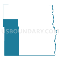
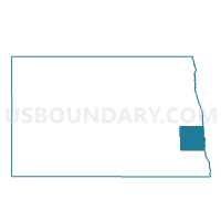
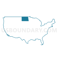
Cass Precinct 22-03, Cass County, North Dakota
About
Outline

Summary
| Unique Area Identifier | 641994 |
| Name | Cass Precinct 22-03 |
| County | Cass County |
| State | North Dakota |
| Area (square miles) | 359.72 |
| Land Area (square miles) | 358.19 |
| Water Area (square miles) | 1.53 |
| % of Land Area | 99.58 |
| % of Water Area | 0.42 |
| Latitude of the Internal Point | 46.84897070 |
| Longtitude of the Internal Point | -97.56287820 |
Maps
Graphs
Select a template below for downloading or customizing gragh for Cass Precinct 22-03, Cass County, North Dakota


Neighbors
Neighoring Voting District (by Name) Neighboring Voting District on the Map
- Barnes 20-12 Voting District, Barnes County, ND
- Barnes 20-13 Voting District, Barnes County, ND
- Cass Precinct 22-01, Cass County, ND
- Cass Precinct 22-02, Cass County, ND
- Cass Precinct 22-05, Cass County, ND
- Cass Precinct 22-08, Cass County, ND
- Ransom 24-02 Voting District, Ransom County, ND
- Ransom 26-06 Voting District, Ransom County, ND
Top 10 Neighboring County Subdivision (by Population) Neighboring County Subdivision on the Map
- Enderlin city, Ransom County, ND (882)
- Tower City city, Cass County, ND (253)
- Buffalo city, Cass County, ND (188)
- Wheatland township, Cass County, ND (158)
- Walburg township, Cass County, ND (152)
- Liberty township, Ransom County, ND (118)
- Gill township, Cass County, ND (117)
- Empire township, Cass County, ND (114)
- Erie township, Cass County, ND (109)
- Greene township, Ransom County, ND (109)
Top 10 Neighboring Place (by Population) Neighboring Place on the Map
- Enderlin city, ND (886)
- Tower City city, ND (253)
- Buffalo city, ND (188)
- Embden CDP, ND (59)
- Alice city, ND (40)
- Ayr city, ND (17)
Top 10 Neighboring Unified School District (by Population) Neighboring Unified School District on the Map
- Central Cass Public School District 17, ND (3,783)
- Northern Cass Public School District 97, ND (2,291)
- Enderlin Area Public School District 24, ND (2,046)
- Maple Valley Public School District 4, ND (1,499)
- Page Public School District 80, ND (627)
Top 10 Neighboring State Legislative District Lower Chamber (by Population) Neighboring State Legislative District Lower Chamber on the Map
- State House District 22, ND (20,531)
- State House District 24, ND (13,443)
- State House District 26, ND (12,887)
- State House District 20, ND (12,348)
Top 10 Neighboring State Legislative District Upper Chamber (by Population) Neighboring State Legislative District Upper Chamber on the Map
- State Senate District 22, ND (20,531)
- State Senate District 24, ND (13,443)
- State Senate District 26, ND (12,887)
- State Senate District 20, ND (12,348)
Top 10 Neighboring 111th Congressional District (by Population) Neighboring 111th Congressional District on the Map
Top 10 Neighboring Census Tract (by Population) Neighboring Census Tract on the Map
- Census Tract 403, Cass County, ND (3,213)
- Census Tract 402, Cass County, ND (2,291)
- Census Tract 401, Cass County, ND (1,955)
- Census Tract 9679, Barnes County, ND (1,695)
- Census Tract 9689, Ransom County, ND (1,688)
- Census Tract 9690, Ransom County, ND (1,511)
Top 10 Neighboring 5-Digit ZIP Code Tabulation Area (by Population) Neighboring 5-Digit ZIP Code Tabulation Area on the Map
- 58027, ND (1,391)
- 58052, ND (581)
- 58079, ND (530)
- 58064, ND (450)
- 58031, ND (414)
- 58071, ND (409)
- 58011, ND (391)
- 58068, ND (321)
- 58029, ND (129)
- 58007, ND (119)